|
||||
| 40
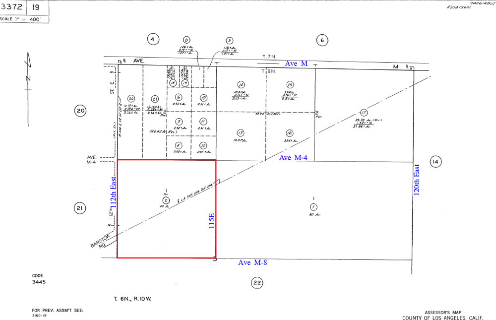
Acres, 115th St East & Ave M-4, e/o Palmdale |
||||
|
|
 |
|||
 |
||||
| Location- |
115th St East & Ave M-4 | |
Area- |
east of Palmdale’s Plant 42 | |
Acres- |
40 acres |
|
APN- |
3372- 019- 002 |
|
Zoning- |
M-4, planned industrial | |
Topography- |
flat & level | |
Dimensions- |
1,320’ x 1,320’ | |
Utilities- |
none to parcel | |
Price- |
$100,000 ($2,500 p/acre) | |
Existing Notes- |
free & clear | |
Terms- |
all cash | |
Remarks- |
Investor path of growth parcel due east of Palmdale.
Parcel is in the City of Palmdale and zoned M-4, planned industrial,
a business park type use. No physical roads to property, but parcel
appears to have legal access, using 112th St East, south from Ave M.
This is a rare situation where the actual roads have not yet caught
up with the roads on maps. Electric is located on Ave M, a 1/4 mile
to the north. Zoning of M-4, longer term, is intended to provide support
to any future airport and the aerospace industry. Parcel is level. General
Plan land use is Industrial.
Highest
& Best use: land banking investment |
|
Safety and Cautions- |
Anyone inspecting, or walking on the property, off the road, should be aware that rattlesnakes and other desert wild life could be in the area. Be careful and use common sense! | |
Directions to Property- |
From
the AV Freeway 14, take the Ave K exit in Lancaster. Go east on Ave
K for approx 10.5 mile to 90th St East. At 90th East, turn right (S)
and go 2 miles to Ave M. At Ave M (there is a street sign), turn left
(E) and go 2 miles to 110th St East. From here Ave M is a dirt road
with the elec line on your left, the north side of Ave M. From 110th
East, go 2/10 of a mile more on Ave M. Stop.
You are now at future 112th St East which will go due south from Ave
M which will be the west border of subject property. See assessors map
at top. |
|